


Earlier this year, I reviewed the Sova3D platform for City Information Modeling (CIM) developed by Sova3D Oy, a Finnish company, which is being implemented by several municipalities in Finland. Despite all the buzz around smart cities and urban digital twins, the actual implementation of advanced technology solutions for urban design and city planning in other countries – including the US — hasn’t really taken off. I see this even in Silicon Valley where I am based, which is home to some of the leading technology companies in the world. The city planning departments here are still, by and large, functioning using older 2D-based applications for their workflows.
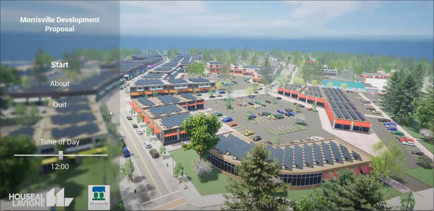
This is why it was heartening to learn of firms like Houseal Lavigne, an urban planning and geospatial design firm (Figure 1), which was not only using cutting edge technologies for its work but was also sharing this know-how with the rest of the planning world. In a three-part webinar series entitled “Technology in Planning,” Houseal Lavigne shared details of its methodologies and toolset as well as several case studies highlighting its technology implementation. These projects range from several cities in the US to Dubai’s metaverse project, as well as a hypothetical city based on Ebenezer Howard’s famous “garden city” concept.
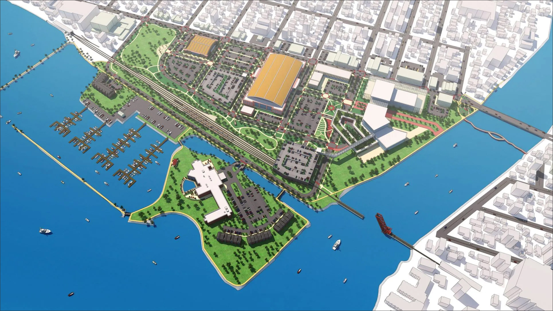
In Houseal Lavigne’s technology toolset for urban planning and geospatial design, Esri’s ArcGIS suite of applications plays a big role, including ArcGIS Pro, ArcGIS CityEngine, ArcGIS Urban, ArcGIS Online, ArcGIS Enterprise, and the more recent product, ArcGIS Maps SDK, which brings ArcGIS into gaming engines. Houseal Lavigne also makes extensive use of SketchUp for modeling its design proposals, such as the redevelopment plan for Downtown Oshkosh that was shown in Figure 1.
Other applications in its toolset include Revit for creating more complex building models when needed; Unreal Engine for exploring design proposals in a gaming environment; Twinmotion for creating photorealistic renderings and animation; Twinit.io, a platform for digital twins; and more recently, Nvidia’s Omniverse, which is an open platform for real-time 3D visualization and simulation. ESRI’s CityEngine has a connector to Omniverse, as do Revit and SketchUp allowing live sync and real-time collaboration. (For more on Omniverse, see the article, “NVIDIA Keynote at SIGGRAPH 2023: Generative AI and Omniverse.”)
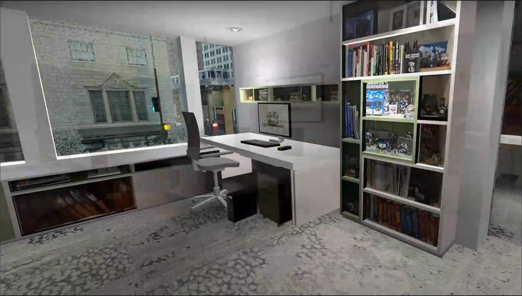
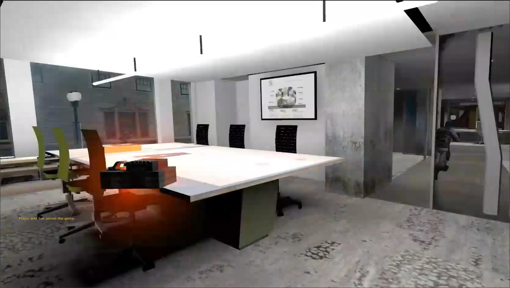
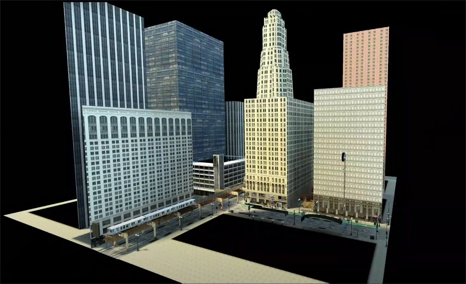
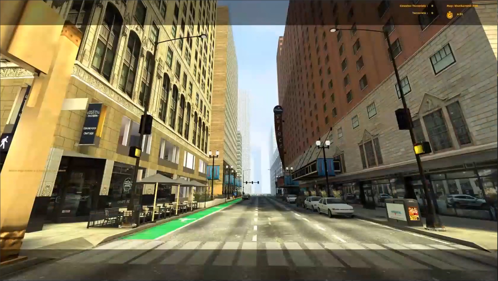
Houseal Lavigne started its exploration of what it refers to as “digital twin” technology by creating a 3D model of its office in Chicago as well as of the area in downtown Chicago where it is located (Figure 2). With the use of photographs, laser scans, and custom textures created using Adobe Photoshop, the project team was able to create a life-like model of their office that could be explored in a gaming engine. The success of this in-house test project gave the firm the confidence and the technical know-how to build out their expertise and offer it to their clients as a core component of its urban planning and geospatial design services.
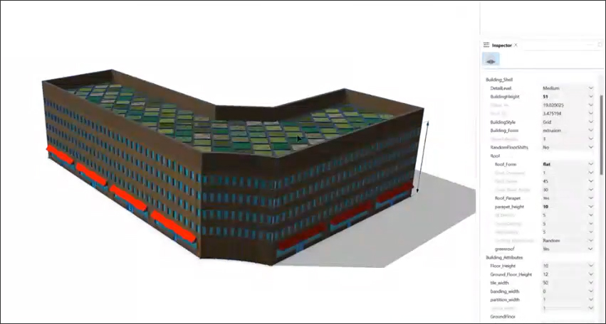
There are some common components to Houseal Lavigne’s technology implementation that it brings to all its projects and services. A key one is what is referred to as “procedural modeling” in CityEngine. With this, you can apply rules or instructions to a base shape like a building footprint or the centerline of a road, and the shape is transformed to a 3D model by the rules. This allows conceptual designs for urban planning to be quickly generated in 3D and visualized without having to painstakingly model each building or road in the plan. The rules have configurable parameters that can be further manipulated to change the geometry of the generated model (Figure 3). The values of these parameters can also be randomly generated in addition to being manually configured, allowing the design concept to have a variety of building shapes and street patterns to make it more lifelike.
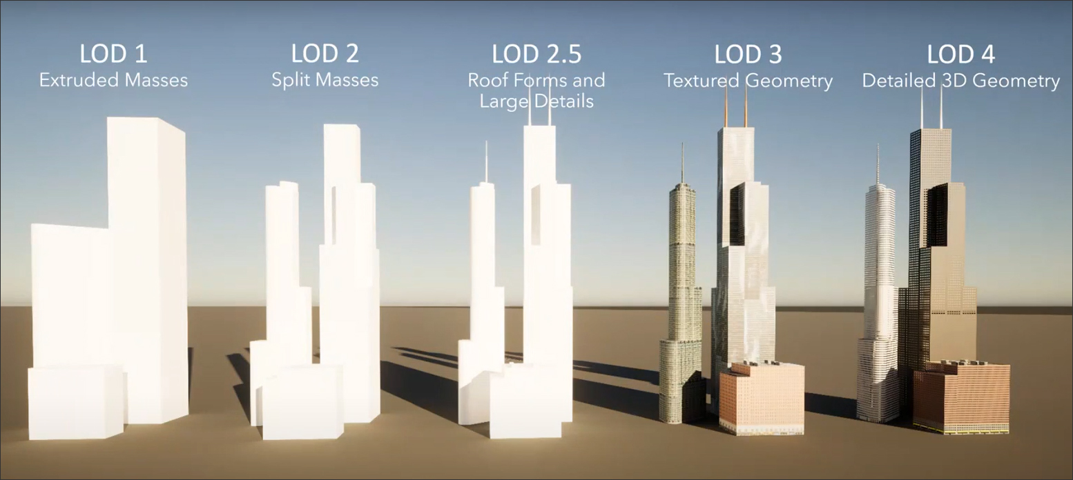
Another concept is that of LOD (Level of Detail) in the model, and typically, a project uses multiple LODs (see Figure 4). The buildings in the background are at LOD 1 or 2, while most of the buildings within the area being designed are at LOD 3 and 4. LOD 5 is reserved for more signature buildings or iconic site elements that typically require manual modeling in applications like Rhino, Revit, or Blender — they cannot be created with procedural modeling in CityEngine.
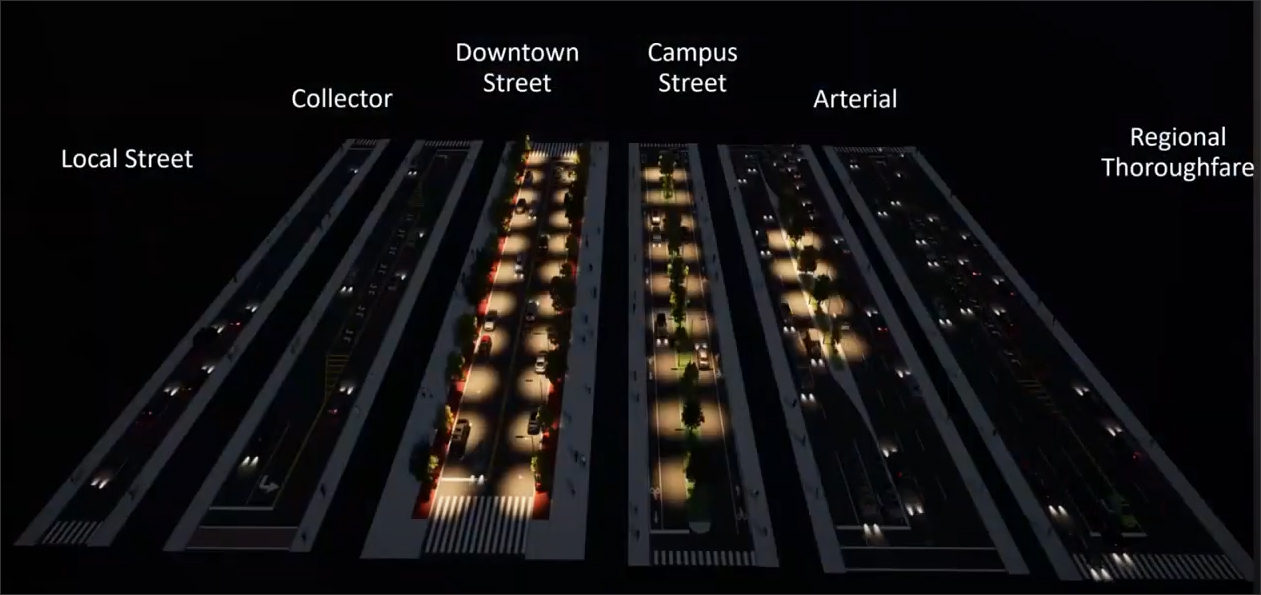
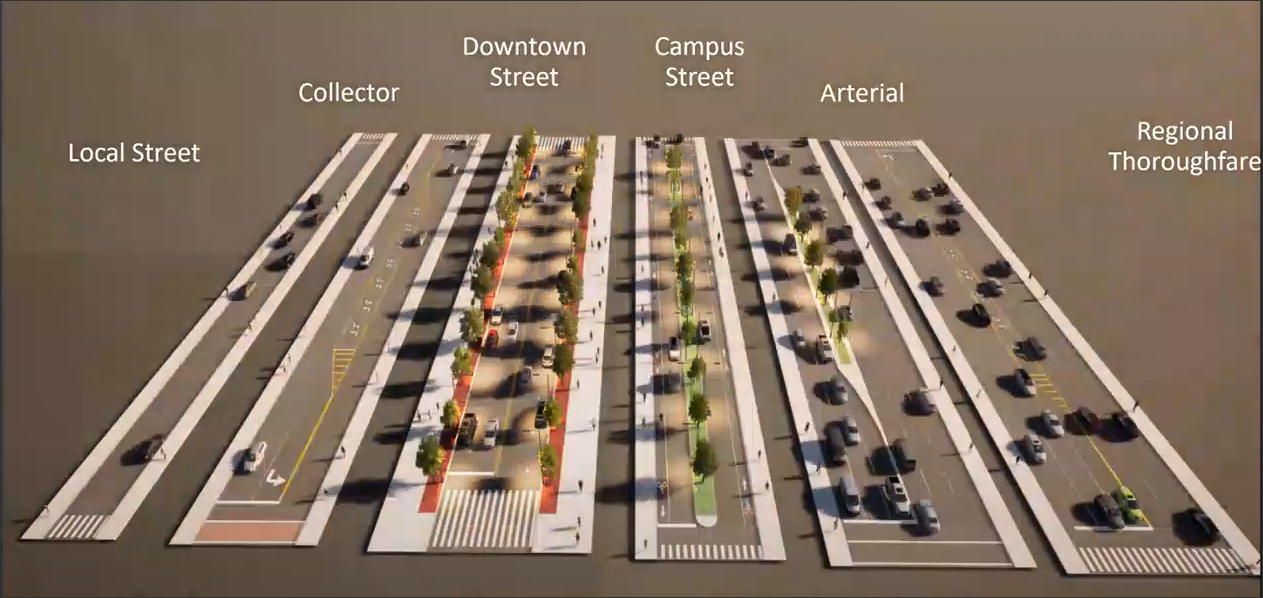
In addition to procedural modeling for buildings, Houseal Lavigne also makes use of typologies for roads (Figure 5). Thus, instead of modeling every single street in a city, it identifies typical road patterns in a local community within that city and uses them to create typologies for a project that can be easily applied to streets within the project area.
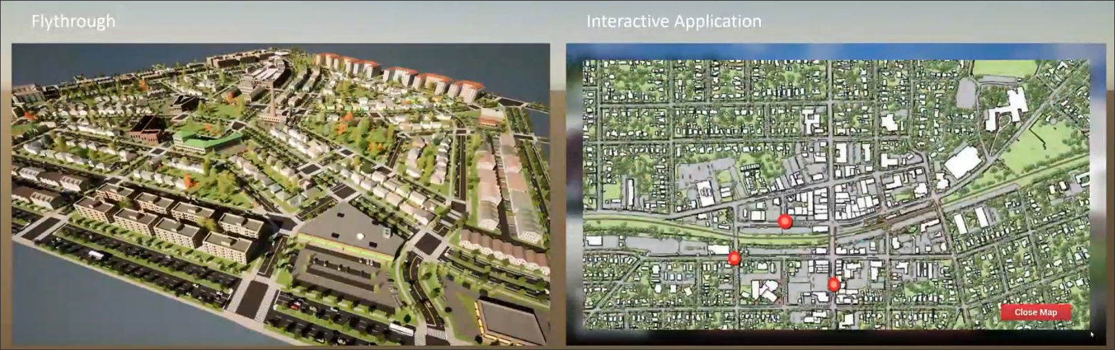
Another core concept is the decision of whether to create a flythrough or build an interactive application for a project (Figure 6). Flythroughs are preconfigured paths that are rendered out as movies and Houseal Lavigne creates them using Omniverse or Twinmotion. An interactive application, on the other hand, allows the user to explore the model and go anywhere they chose to go. It is created with Unreal Engine and is depicted by a character in the scene. Houseal Lavigne can also program additional interactivity in the gaming engine, including development proposals and phasing.
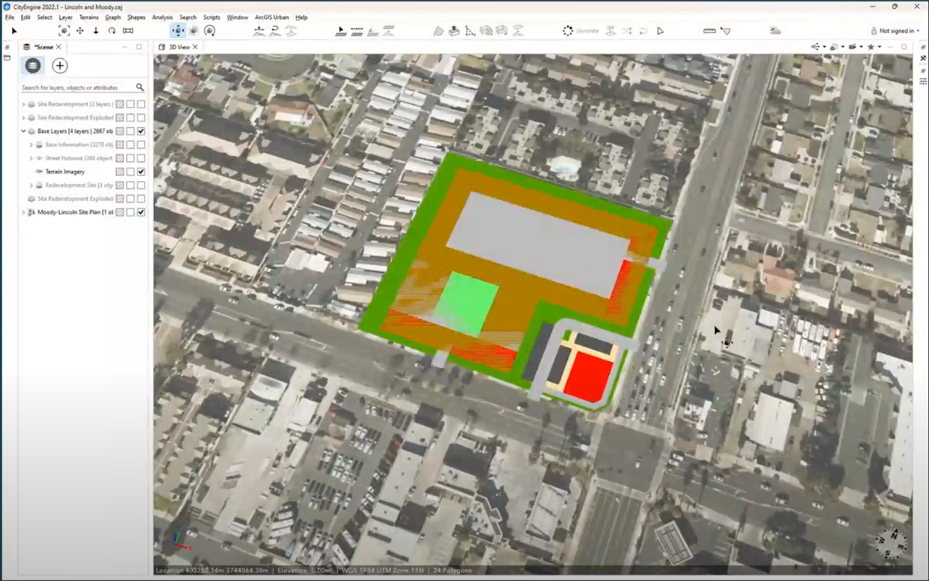
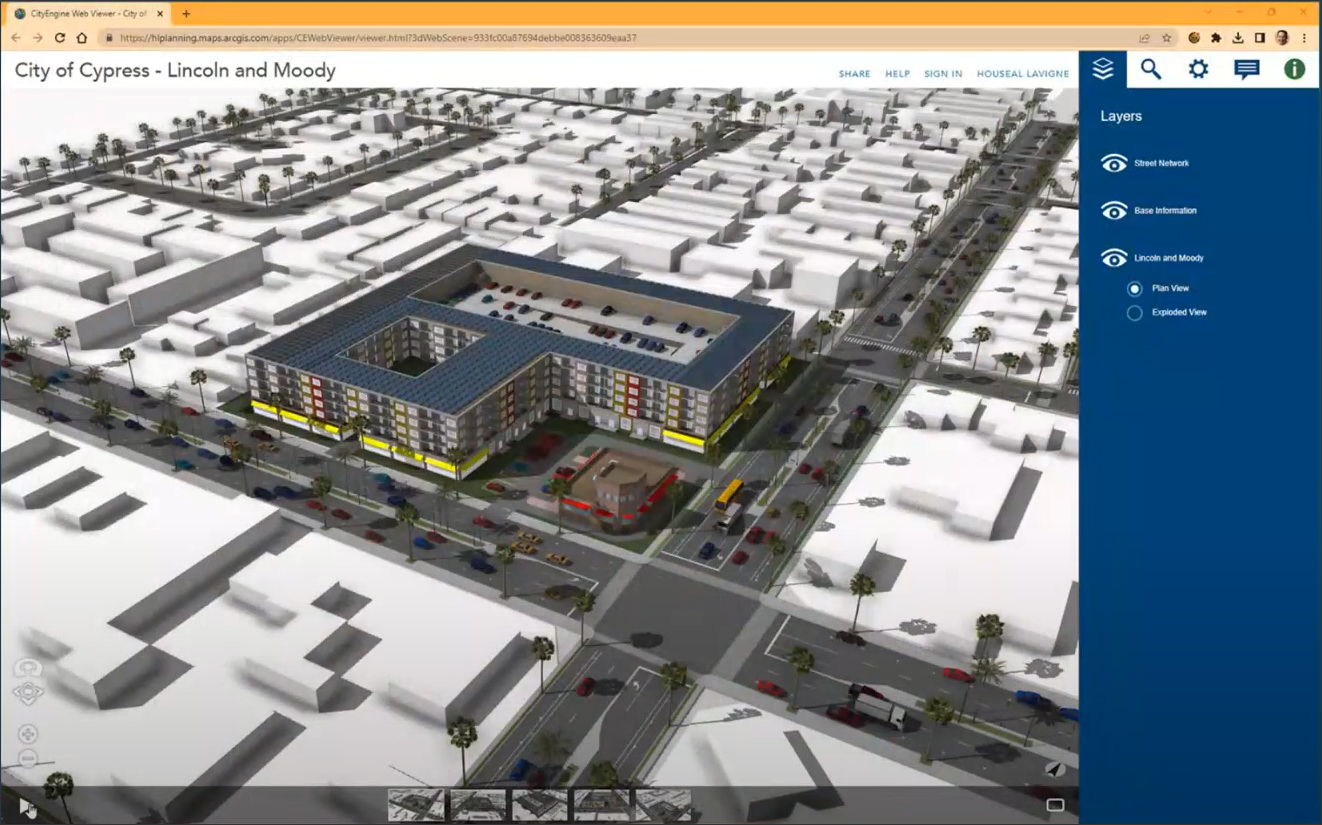
Houseal Lavigne showed several of its projects in which it was implementing these concepts and technologies. The first case study was the planning and visualization of a housing element in Cypress, California (Figure 7). The city had been mandated by the state to provide about 4,000 housing units throughout the city. Using CityEngine, Houseal Lavigne identified a strip mall as a site that could accommodate about 200 dwelling units. The design of the proposed housing complex was started in SketchUp and then brought back into CityEngine where it was refined with the help of the dashboards and spatial intelligence of the application. The proposal was shared with the client as a 3D web scene that they were able to browse through and query to get information on aspects such as dwelling size, construction cost, etc.
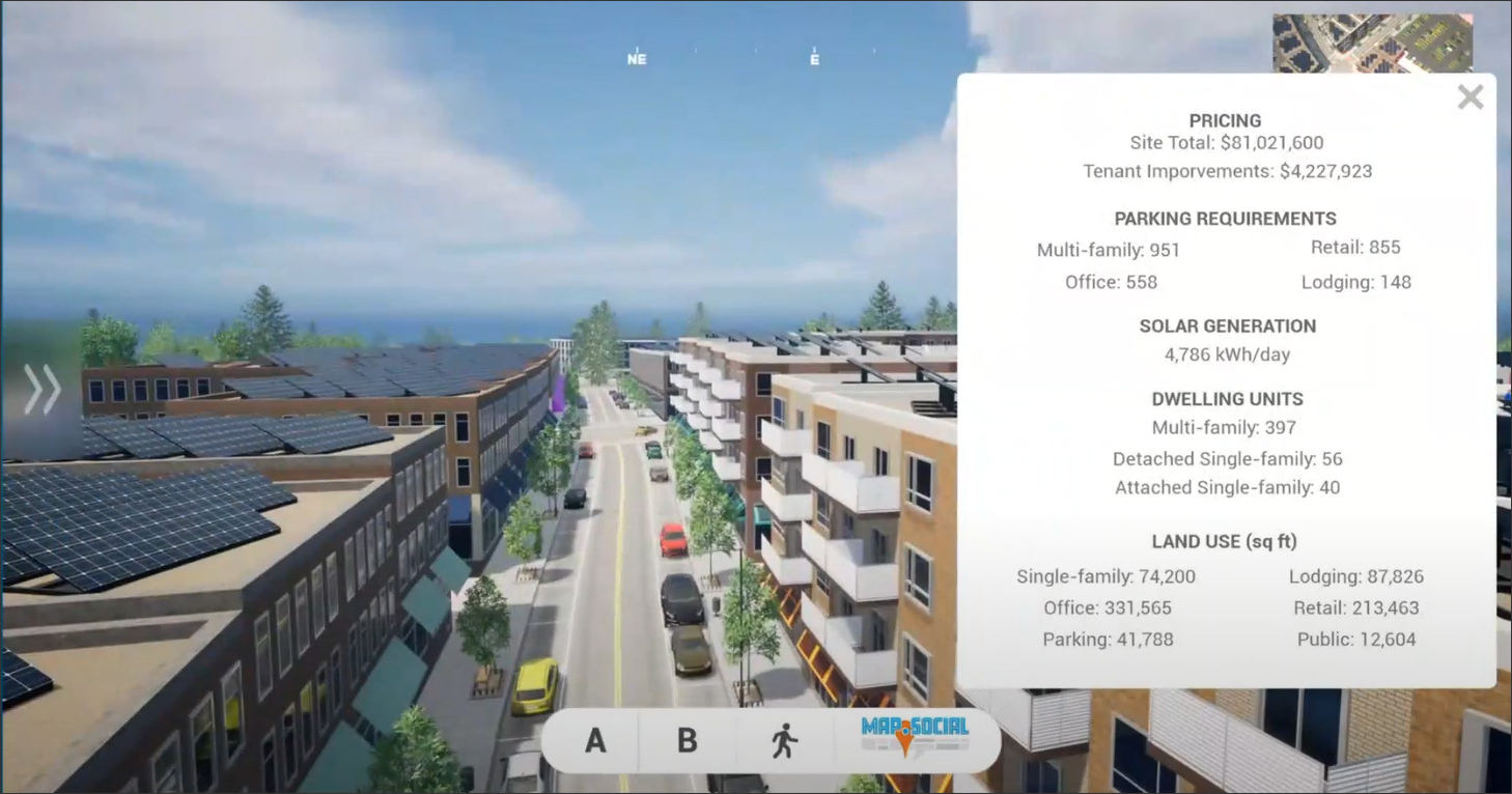
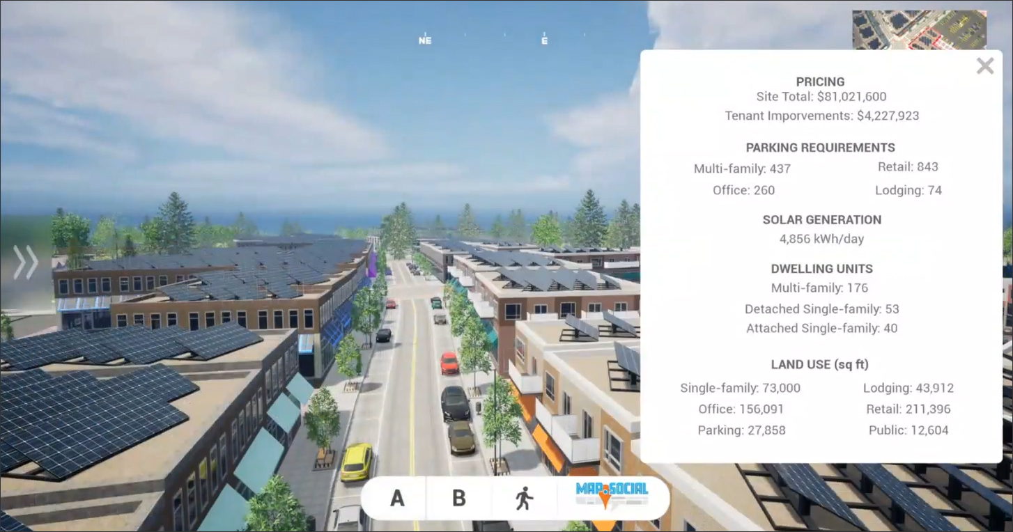
Another case study was a redevelopment project for the town of Morrisville in North Carolina, which wanted a traditional downtown area to provide a focal point for the community. There was an impasse within the community leadership on whether the town center should comprise one-story buildings with surface parking or multi-story buildings with parking garages. While the denser option would be more efficient and provide a better use of space, there was a fear that it might create an unpleasant “cavern-like” caged-in effect. Houseal Lavigne created both options, using CityEngine and SketchUp for the design and Photoshop for creating realistic textures to apply to the model, and published both scenarios in gaming engines that could be explored interactively (Figure 8). It helped the community to arrive at a decision about how to proceed, and they finally went with the denser, multi-story option after finding that it did not create the cavern-like feeling they had feared.
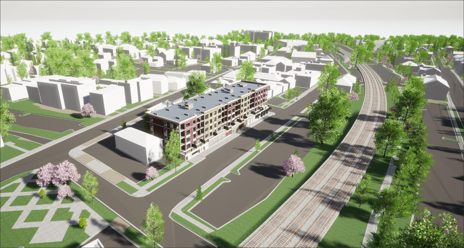
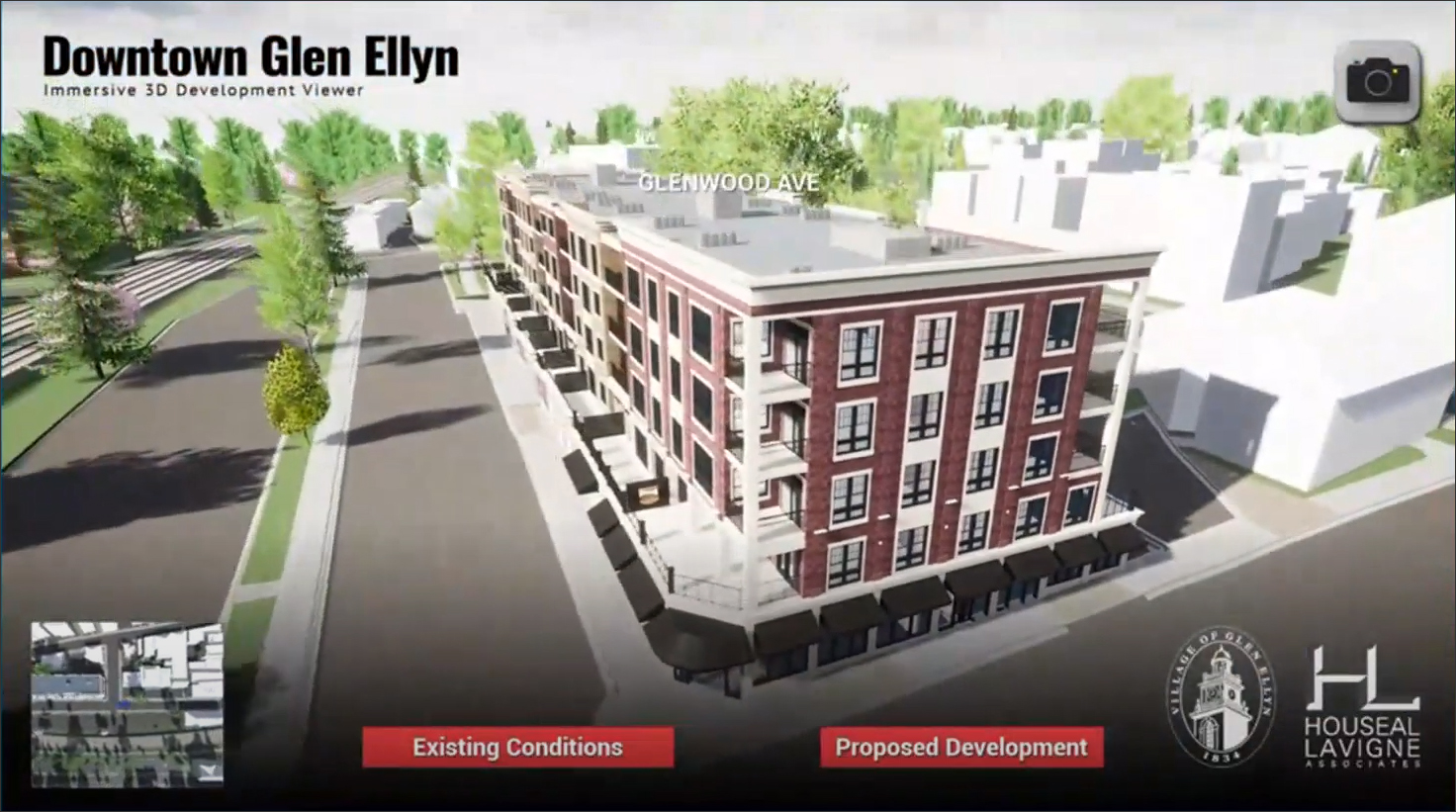
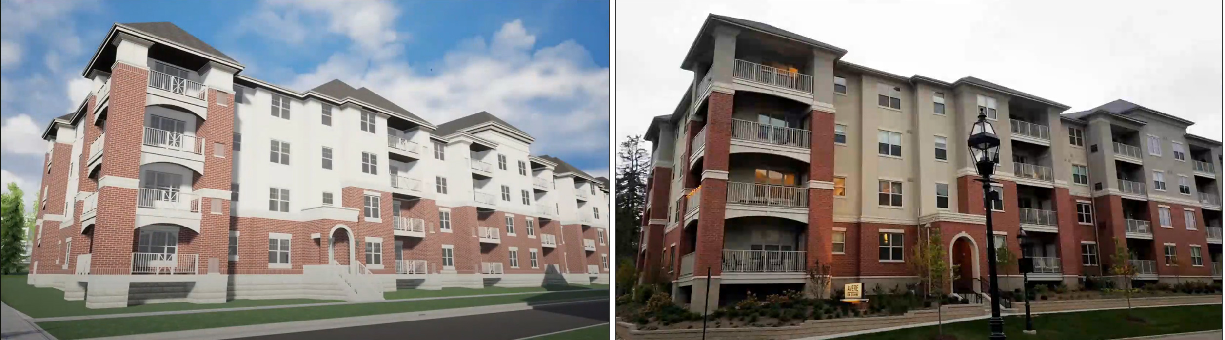
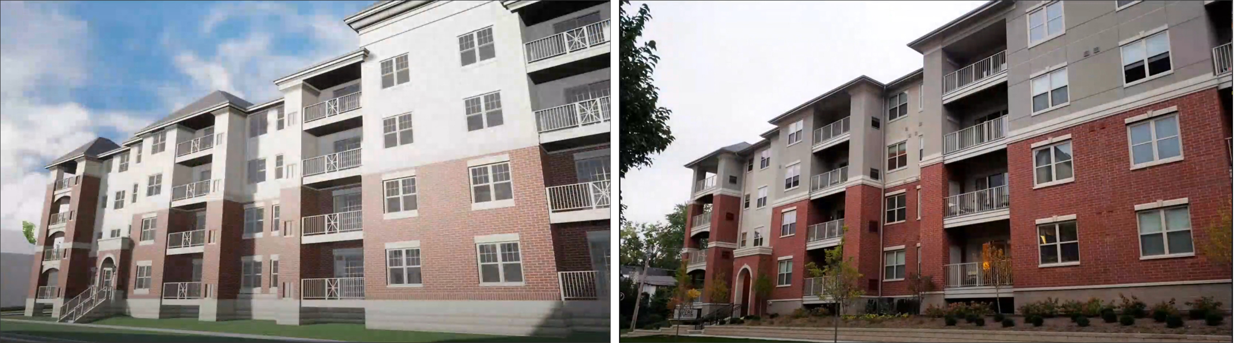
A similar project was the design and evaluation of a new development for the village of Glen Ellyn in Illinois (Figure 9). The village had a historic downtown area whose character it wanted to preserve and at the same time expand to include new businesses and increase residential density. The key tools for the design were again CityEngine and SketchUp. For this project, Houseal Lavigne created an interactive web application that could be used by residents to explore the planned development. It allowed the proposed changes to be contrasted with the existing conditions, which were also captured in the web application and could be explored interactively. Figure 10 shows two examples contrasting the views in the gaming engine with what was actually built, showing how close the design was to reality.
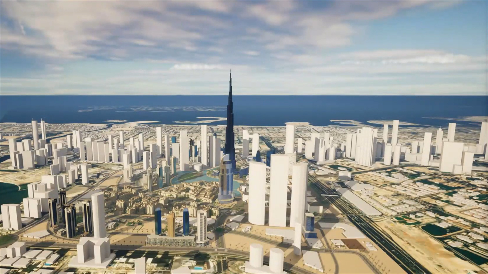
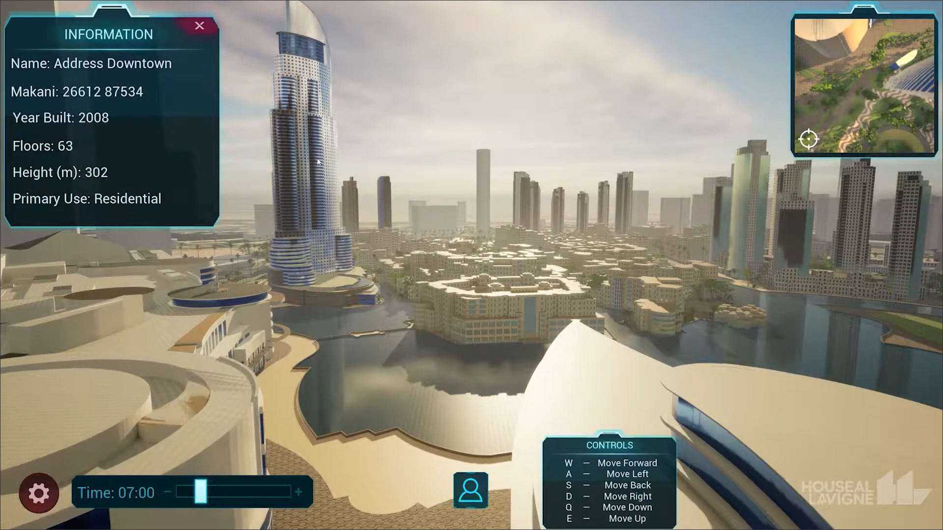
A more futuristic example is the Dubai Metaverse project, for which Houseal Lavigne developed a digital twin as a proof of concept to showcase how the municipality of Dubai could leverage its GIS data and transform it into an immersive 3D world (Figure 11). The resulting city model is a blend of buildings pulled in from online data sources as well as buildings that were modeled. The model and the visuals were packaged into a metaverse app built for Dubai with four preliminary use cases to start with: Explore, which allows the user to move freely throughout downtown Dubai, zoom in and out, and get information on a building by clicking on it; Routing, which determine the route between two locations, a feature that is especially helpful for emergency services; Planning, which allows the user to evaluate two different scenarios for the development of a vacant site; and Real Estate, which uses GIS information to show where space is currently available for lease in the city.
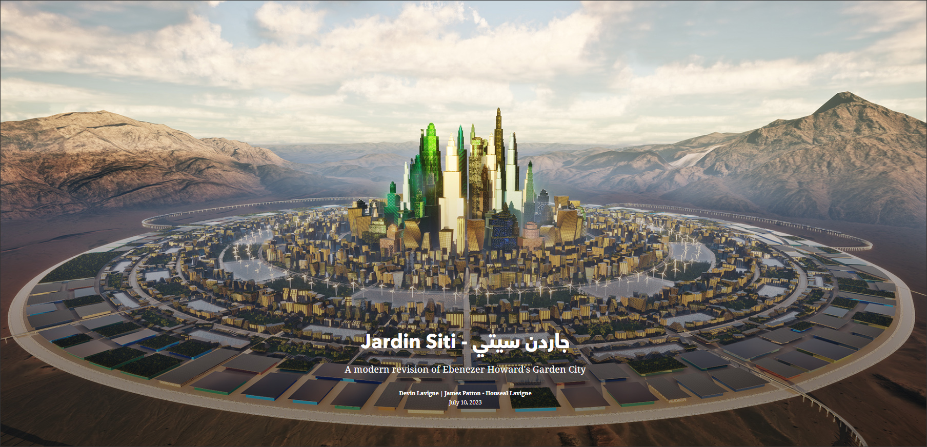
And finally, Houseal Lavigne has developed a master plan for a hypothetical city based on Ebenezer Howard’s “garden city” vision which can be explored in a gaming environment (Figure 12). Called Jardin Siti, it was built using similar technology workflows as Houseal Lavigne’s other projects with CityEngine, Unreal Engine, and Omniverse. The concept maintains the spirit of Howard's vision while addressing its shortcomings — such as mobility, scalability, monotony, and economic equity — and adapting to the needs of the modern era. For this project, extensive use was made of CityEngine’s procedural modeling capabilities, allowing the road network and the diverse building stock to be generated from blocks and parcels that were created from a circular graph network as the starting point. A detailed description of this project can be seen at: https://storymaps.arcgis.com/stories/0d588edf9c194cd7a378f55d77c3bd86.
For Houseal Lavigne, the use of cutting edge technologies in its urban planning and geospatial design work helps it as a firm to make smarter decisions and better plans — in addition to it simply being a lot of fun learning and using the software. I also found it very commendable that the firm was sharing the details of its tools and workflows that other urban design firms can learn from. The more these techniques are adopted in planning and designing our cities, the faster we can have actual smart cities that are intelligently operated, making them more sustainable and enhancing the quality of life for their residents.
Lachmi Khemlani is founder and editor of AECbytes. She has a Ph.D. in Architecture from UC Berkeley, specializing in intelligent building modeling, and consults and writes on AEC technology.
Have comments or feedback on this article? Visit its AECbytes blog posting to share them with other readers or see what others have to say.
AECbytes content should not be reproduced on any other website, blog, print publication, or newsletter without permission.